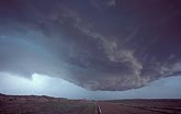
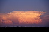
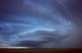
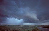
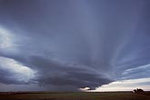
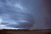
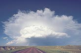
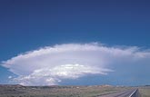
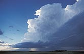
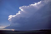
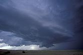
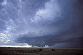
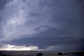
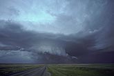
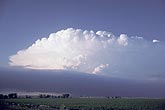
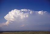
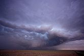
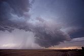
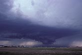
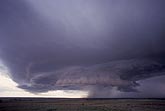
Supercells: Stock photos of Cumulonimbus clouds that depict classic supercell thunderstorm type features. Most are overview examples but a few show the underside structure and storm-scale rotation.

  • Interpreting storm cloud features: mesocyclone on an HP supercell
    • W012020S
    • +
  • A distant supercell storm cloud has exploded to the east at sunset
    • W011794Z
    • +
  • HP supercell, with tilted mesocyclone and rotating updraft column
    • W011709Z
    • +
  • Wide-angle view of a typical HP supercell hailstorm
    • W011693S
    • +
  • A cyclic, high-precipitation supercell storm with rain at back
    • W011681Z
    • +
  • Supercell with a pronounced mesocyclone (banded circular region)
    • W011606S
    • +
  • Supercell storm cloud: features of a weakening storm
    • W010853Z
    • +
  • Supercell storm cloud anatomy explored: tight organization
    • W010848Z
    • +
  • Supercell type severe storm with short inflow base and no flanking line
    • W001627Z
    • +
  • This hybrid supercell is building in dry but very unstable air
    • W001582Z
    • +
  • A classic supercell severe storm type with dark, rain-free inflow axis
    • W001418S
    • +
  • Supercell storm cloud overview showing circular updraft base
    • W001353S
    • +
  • Side view of a classic supercell wall cloud
    • W001336S
    • +
  • HP supercell thunderstorm type with a rotating wall cloud
    • W993547S
    • +
  • Rapid growth produces an unfrozen crown on this classic supercell
    • W992116S
    • +
  • Cumuliform crown on a supercell storm due to extreme rate of growth
    • W992089S
    • +
  • A supercell with a dark cloud arc ahead of rain and hail
    • W991822S
    • +
  • An HP supercell storm with low base and wall cloud
    • W991801Z
    • +
  • A hailstorm is brewing: a high-precipitation supercell storm
    • W991755S
    • +
  • Weakening HP supercell storm with the wall cloud east of the rain
    • W991084Z
    • +